The real estate industry is experiencing a digital transformation, and nowhere is this more evident than in how properties are visualized and presented to potential buyers. The traditional method of using static PDF maps is rapidly being replaced by interactive 3D plot view technology. But what makes a 3D plot viewer so much more effective than conventional PDF maps?
In this comprehensive guide, we'll explore why 3D plot visualization is revolutionizing property sales, how it compares to traditional PDF maps, and why real estate developers are making the switch to interactive 3D plot view platforms like Plotex.
Understanding 3D Plot View vs PDF Maps
What is a 3D Plot View?
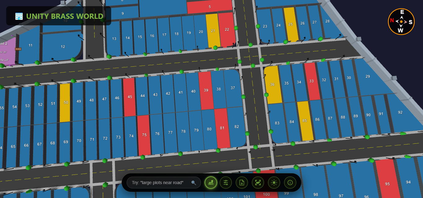
A 3D plot view is an interactive digital visualization that allows users to explore land plots and properties in three dimensions. Unlike static images, an interactive 3D plot viewer enables users to:
- Rotate and zoom the property from any angle
- Click on individual plots to see detailed information
- Measure distances and areas in real-time
- Filter properties by availability, size, or price
- Experience the property layout as if walking through it
- View topographic features and elevation changes
- Access the visualization from any device, anywhere
What are PDF Maps?
PDF maps are static, two-dimensional documents that show property layouts, boundaries, and dimensions. While they've been the industry standard for decades, PDF plot maps have significant limitations:
- Fixed viewpoint with no interactivity
- Difficult to understand spatial relationships
- Require technical knowledge to interpret symbols and notations
- Cannot be easily updated or modified
- Poor viewing experience on mobile devices
- No real-time measurement or filtering capabilities
- Limited engagement and user experience
Head-to-Head: 3D Plot View vs PDF Maps Comparison
| Feature | 3D Plot View | PDF Maps |
|---|---|---|
| Interactivity | Fully interactive: rotate, zoom, click, filter | Static image only, no interaction |
| Visualization | Realistic 3D rendering with depth and perspective | Flat 2D technical drawing |
| User Experience | Intuitive, engaging, easy to understand | Requires technical expertise to interpret |
| Mobile Accessibility | Optimized for touch, responsive design | Difficult to navigate on small screens |
| Measurements | Real-time, interactive measurements | Fixed dimensions, manual calculation needed |
| Updates | Instant updates, always current | Requires new file generation and distribution |
| Sharing | Simple link, QR code, or embed option | Large file downloads, version confusion |
| Analytics | Track views, popular plots, user behavior | No tracking or analytics possible |
| Availability Status | Real-time color coding, instant updates | Outdated immediately after a sale |
| Client Engagement | High engagement, immersive experience | Low engagement, passive viewing |
10 Key Advantages of 3D Plot View Over PDF Maps
1. Instant Visual Understanding
With an interactive 3D plot view, potential buyers immediately understand property layouts without needing to interpret technical symbols or measurements. The three-dimensional perspective shows exactly how plots relate to each other, road access, and surrounding features. This instant clarity reduces buyer confusion and accelerates decision-making.
PDF maps, on the other hand, require buyers to mentally convert 2D technical drawings into spatial understanding—a skill not everyone possesses. This cognitive barrier often leads to misunderstandings and hesitation.
2. Superior Mobile Experience
Today's property buyers conduct research on smartphones and tablets. 3D plot viewers are built with mobile-first design principles, offering intuitive touch controls, pinch-to-zoom functionality, and responsive interfaces that adapt to any screen size.
PDF maps become nearly unusable on mobile devices. Zooming is clunky, panning is difficult, and text becomes illegible. This poor mobile experience can cost you sales in an increasingly mobile-first market.
3. Real-Time Property Availability
A major advantage of 3D plot visualization is dynamic status updates. Plots can be color-coded as available (green), reserved (yellow), or sold (red), with changes reflected instantly across all user devices. Buyers always see current availability.
PDF maps become outdated the moment a property status changes. Developers must create and distribute new versions repeatedly, leading to confusion when multiple PDF versions circulate among buyers and agents.
4. Interactive Measurement Tools
Modern 3D plot view platforms include built-in measurement tools. Users can click between any two points to see exact distances, calculate plot areas, and verify dimensions—all in real-time without manual calculations.
PDF maps show fixed measurements that may not answer every buyer's specific question. Want to know the distance from a plot to the nearest amenity? You'll need a ruler and manual calculations with PDF maps.
5. Seamless Sharing and Collaboration
Sharing a 3D plot viewer is as simple as sending a link or displaying a QR code. Recipients access the latest version instantly, with no downloads required. Multiple stakeholders can view and discuss the same live visualization simultaneously.
PDF maps require file downloads, consume storage space, and create version control nightmares. Email attachments may be too large, and recipients might view outdated versions without realizing it.
6. Enhanced Buyer Engagement
The interactive nature of 3D plot visualization keeps potential buyers engaged longer. They explore properties actively rather than passively viewing static images. This increased engagement time correlates directly with higher conversion rates.
Studies show that buyers spend 60% more time exploring properties through interactive 3D plot view compared to PDF maps, leading to more informed decisions and stronger purchase intent.
7. Built-In Analytics and Insights
A 3D plot viewer tracks which properties receive the most views, how long users spend exploring each plot, and which features attract attention. This data helps developers optimize pricing, marketing strategies, and sales approaches.
PDF maps provide zero insights into user behavior. You'll never know which plots generated interest, which were overlooked, or how buyers interacted with your property information.
8. Professional Brand Image
Presenting properties through an interactive 3D plot view positions your development as modern, innovative, and customer-focused. It demonstrates investment in technology and buyer experience, elevating your brand above competitors using outdated PDF maps.
Relying on PDF maps can make your business appear behind the times, especially when competing developers showcase properties with cutting-edge 3D visualization technology.
9. Accessibility from Anywhere
3D plot view platforms are cloud-based and accessible via simple web links. Potential buyers can explore properties from anywhere in the world, at any time, on any device—no software installation required.
This global accessibility is particularly valuable for NRI (Non-Resident Indian) investors, remote buyers, and international clients who cannot visit properties in person.
10. Cost-Effective Long-Term Solution
While initial setup of a 3D plot viewer may seem like an investment, it eliminates ongoing costs of printing updated PDF maps, distributing physical copies, and managing version control. Digital updates are instant and free.
PDF maps incur continuous costs for revisions, printing, and distribution. Every status change means new printing costs and manual distribution efforts.
Real-World Impact: 3D Plot View Success Stories
Case Study: Developer Reduces Sales Cycle by 45%
A residential land developer in Pune replaced PDF maps with Plotex's interactive 3D plot view and saw remarkable results: 45% reduction in average sales cycle time, 68% increase in online inquiries, 82% of buyers made decisions without site visits, and 3.2x more social media shares compared to PDF brochures.
These results aren't isolated. Developers using 3D plot visualization consistently report faster sales, higher buyer confidence, and improved conversion rates compared to traditional PDF map presentations.
Technical Advantages of 3D Plot View Technology
Scalability and Performance
Modern 3D plot viewers utilize optimized rendering engines that load quickly even on slower internet connections. Unlike large PDF files that can be slow to download and open, 3D plot view platforms stream data efficiently, providing instant access.
Cross-Platform Compatibility
A quality interactive 3D plot view works seamlessly across Windows, Mac, iOS, Android, and all major web browsers. This universal compatibility ensures every potential buyer can access your properties regardless of their device or operating system.
Integration Capabilities
3D plot visualization platforms can integrate with CRM systems, inquiry forms, payment gateways, and marketing automation tools. This connectivity creates a seamless sales funnel from initial viewing to final purchase.
PDF maps are isolated documents with no integration capabilities, creating disconnected buyer journeys and manual data entry requirements.
Addressing Common Concerns About 3D Plot View
"Are 3D plot viewers difficult to use?"
Not at all. Modern 3D plot view platforms like Plotex are designed for intuitive use. If someone can use Google Maps, they can navigate a 3D plot viewer. Simple controls like click-and-drag rotation, mouse wheel zooming, and tap-to-select on mobile make the experience natural and effortless.
"Do I need to abandon PDF maps completely?"
While interactive 3D plot view should become your primary visualization tool, PDF maps still serve purposes for legal documentation, archival records, and situations requiring official stamped documents. The best approach is using 3D visualization for marketing and sales while maintaining PDFs for legal compliance.
"What about buyers who prefer traditional methods?"
Even traditional buyers appreciate the clarity of 3D plot visualization. The technology is designed to be so intuitive that no technical knowledge is required. In fact, older buyers often find 3D plot view easier to understand than complex technical PDF drawings.
"Is 3D plot view expensive to implement?"
With platforms like Plotex, implementing 3D plot view technology is surprisingly affordable. When you consider eliminated printing costs, faster sales cycles, and reduced site visit requirements, the ROI is typically realized within the first few sales.
How to Transition from PDF Maps to 3D Plot View
Making the switch to interactive 3D plot view is straightforward:
- Prepare Your Data: Gather existing plot layouts, dimensions, and property information. Most PDF maps or CAD files can be converted to 3D format.
- Choose a Platform: Select a 3D plot viewer platform that offers the features you need—Plotex provides comprehensive visualization with analytics, sharing, and mobile optimization.
- Upload and Configure: Most platforms handle the technical conversion. You simply upload your data and customize colors, labels, and property details.
- Train Your Team: While 3D plot view is intuitive for users, ensure your sales team understands how to showcase its features effectively.
- Launch and Share: Distribute your 3D plot viewer link through your website, social media, WhatsApp, email campaigns, and QR codes on marketing materials.
- Monitor Analytics: Use built-in analytics to understand buyer behavior and optimize your sales strategy.
The Future is Interactive: Why 3D Plot View is the Industry Standard
The real estate industry's shift from PDF maps to interactive 3D plot view isn't a temporary trend—it's the new standard. As buyers become increasingly digital-savvy and expect immersive online experiences, static PDF maps will become obsolete.
Forward-thinking developers recognize that 3D plot visualization isn't just a nice-to-have feature; it's a competitive necessity. Properties showcased with interactive 3D plot view receive more attention, generate more qualified leads, and sell faster than those presented with traditional PDF maps.
Key Takeaway: Interactive 3D plot view offers superior visualization, better mobile experience, real-time updates, built-in analytics, and higher buyer engagement compared to static PDF maps. For modern real estate sales, 3D visualization isn't optional—it's essential.
Getting Started with 3D Plot View Technology
Ready to move beyond PDF maps and embrace interactive 3D plot visualization? Plotex makes the transition simple and affordable. Our platform transforms your property data into stunning, interactive 3D plot views that work perfectly on any device.
Whether you're a developer with hundreds of plots or a builder with a boutique project, 3D plot view technology provides the competitive edge you need in today's digital-first real estate market.
The choice is clear: continue using outdated PDF maps and watch competitors capture market share, or adopt interactive 3D plot view technology and deliver the immersive, engaging property viewing experience modern buyers expect.

